Futuristic, 4-dimensional Approach Designed to Detect Internal Damage in Highways, Tunnels
How to maintain aging infrastructure has become a major challenge in Japan and many other parts of the world. Associate Professor Tsukasa Mizutani of UTokyo-IIS proposes detecting damage through what he calls "four-dimensional transparentization technology" (which incorporates a temporal axis and the use of radar) at an early stage. This approach is essential if governments want to reduce the cost of infrastructure maintenance.
Maintenance of Old Infrastructure Pressing Issue
Japan now faces the formidable task of maintaining its aging infrastructure, with many sections built during the nation's era of high economic growth five decades ago. The severity of this challenge was highlighted in 2012 when hundreds of concrete ceiling panels of the Sasago Tunnel on the Chuo Expressway collapsed, killing nine people and injuring two others.
Mizutani was chosen to be a researcher of the Cabinet Office's Strategic Innovation Program (SIP), which was launched two years after the disaster to look into how to spark innovation in maintaining the nation's infrastructure. At that time, high expectations were placed on the introduction of pioneering electromagnetic wave technology for infrastructure maintenance. His selection, therefore, was attributed to his graduate studies at UTokyo's Graduate School of Engineering, where he analyzed electromagnetic waves emitted by antennas installed along railways for weather observation.
"It is important to detect internal damage of structures at an early stage, because, by the time damage becomes visible and detected, the structure is often in a serious condition, requiring major overhauls that take months, if not years," Mizutani explained. "Thus, preventive maintenance with the use of radar is crucial to avoid traffic disruption and reduce costs."
According to an estimate made in 2018 by the Ministry of Land, Infrastructure, Transport and Tourism, the cost of breakdown maintenance is projected to reach about 280 trillion yen over the 30 years through 2048. On the other hand, the same estimate shows that preventive maintenance can potentially reduce the cost by about 30%, bringing it down to around 190 trillion yen.
Since his involvement in SIP, Mizutani has been developing technologies to safely and cost-effectively detect damage at an early stage by seeing through the infrastructure's interior. He has become one of the pioneers in this field.
Aiming to Create 'X-ray or MRI' for Roads
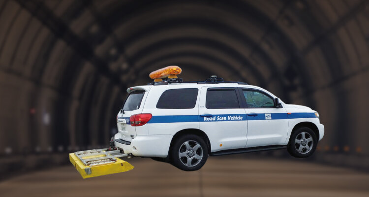
Mizutani employs two kinds of ground penetrating radar (GPR), which is a non-destructive subsurface inspection technology based on the reflection of electromagnetic waves.
One is a radar system mounted on a vehicle that is capable of monitoring the health of infrastructure at speeds up to 80 kilometers per hour without disrupting traffic. This multi-channel system consists of several antennas aligned in a transverse direction, which corresponds to the radar channels, to construct dense 3D radar data. By adding a temporal axis, it becomes four-dimensional, enabling the detection of small amounts of damage that develop into major problems by surveying the same infrastructure over time. The other type is a portable radar equipped with a smartphone, which serves as a display and processor for the system.
Typically, radar systems are designed for real-time human monitoring of the acquired data. Mizutani, however, is attempting to automate the monitoring process by using algorithms and artificial intelligence. His aim is to automatically pinpoint damage by distinguishing it from buried objects such as pipes.
"Our research is going pretty well," Mizutani said, referring to demonstration results using an experimental test track. "We are able to see through the internal sections of structures, identifying the location of buried pipes and damage."
Fluoroscopic video of the interior of the bridge using radar (infrastructure version of X-ray, MRI view) Research by Takanori IMAI, 2nd year Master's student in Mizutani Lab
Overcoming Hurdles to See Unseeable
The task of making this technology more accurate still faces obstacles. Even a 1% error rate translates to errors of 10,000 kilometers out of every 1 million kilometers of road. Enhancing precision is a daunting task. One example is developing optimal algorithms to eliminate noise in data caused by differences in the properties of antennas.
AI is used to distinguish objects in constructed images that cannot be easily discerned with the human eye, such as differentiating between an underground cave and a rock. However, a significant challenge arises in the form of insufficient teaching data for AI, as correct data to identify damage is not readily available. Mizutani is compensating for this shortfall by incorporating simulation data, and by combining AI with signal and image-processing technologies.
Another challenge involves rapidly filtering out irrelevant data for damage detection to reduce the volume of calculations, he added.
Future Lies with Use of Driverless Vehicles
Mizutani's ultimate goal is to create a real-time underground version of Google Maps while gathering data from a traveling vehicle.
"At present, Google Maps is used as primary data for various purposes, such as searching for shops and restaurants, navigation and specific research mapping," Mizutani said. "I believe that an underground version could serve as a primary dataset, triggering a revolution in the construction sector."
There is a significant demand for digital transformation in the construction sector, which often is characterized by outdated and dangerous practices. For instance, if the location of underground rocks can be detected in advance, piles can be driven into the ground in a way to avoid the rocks. "Having primary underground data will be indispensable if we want to realize fully unmanned operations in this sector," Mizutani added.
The key to creating this kind of map lies in the introduction of driverless vehicles. China and the United States have already launched services using autonomous vehicle prototypes. If Japan follows suit and adopts such a service, autonomous vehicles can be equipped with radar and various other sensors. This would enable automated sensing of underground areas around the clock without interruption, and allow for repeated measurements of the same sections to gauge temporal changes.
"If such a system is completed, I would like to showcase it as Japan's first automated infrastructure maintenance system to the world, which is facing infrastructure maintenance challenges," Mizutani said. Such an achievement could lead to the establishment of a new academic domain which he called "infrastructure transparentization engineering," which he hopes to pioneer.
Augmented reality representation of the road surface below on Google Street View
Research by Muhammad Moosa KAZIM, 2nd year Master's student in Mizutani Lab
Short Dialogue
Yamakawa(→'Seeing'with High-speed Vision [UTokyo-IIS Bulletin Vol.12] ):
We both graduated from a National Institute of Technology (Kosen) before entering UTokyo. Creating algorithms to mimic human senses is very important, and we honed that engineering sense while we attended the Kosen. That's a great asset.
Mizutani:
Yes, at the Kosen we were able to link theories to practical use. We acquired a sense of how to apply formulas, instead of memorizing them for the sake of learning. And we both hail from families with engineering backgrounds, which helped us learn which approaches work best. Translating what human being are thinking into the form of algorithms is very interesting.
Yamakawa:
In that sense, I am using external force and tactile sensors and deep learning, in addition to high-speed vision, to enable a robot hand to recognize whether a moving object is fragile when it attempts to grab it.