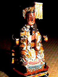
(Admiral Zheng He)
There have already been some general studies on the history of Southeast Asia. However, most of them were not from the architectural point of view, but from social-cultural point of view, done by social scientists. The first monumental work on the general history of Southeast Asia was done by D.G.E. Hall in the 1960s, and his book remains as the most important reference for Southeast Asian studies. He was followed by several scholars, such as: Anthony Reid (on "total history" between 1450-1680), Kenneth R. Hall (on maritime trade and state development), D.R. SarDesai (on traditional history and current affairs), Robert R. Reed (on indigenous urbanism), Chang Tsuen-Kung (on the Chinese settlements), and many more.
Some architects and planners have been conducting various aspect of Southeast Asian urbanity and architecture too. T.G. McGee initiated the study from urban-geography perspective. Hideo Izumida focused himself on the study of Colonial architecture in South and Southeast Asia. Huang Chun-ming did an investigation on the Chinatown in East and Southeast Asia. Also there were some architects, planners, and conservationists, who did special research on different localities in Southeast Asia.
Because there has been no comprehensive study about the morphology of the cities in this region, then I did field research in some coastal cities in southern China (Fuzhou, Quanzhou, Xiamen in Fujian province), peninsular Malaysia (Penang, Malaka), Singapore, southern Thailand (Pattani, Phuket), western Kalimantan (Pontianak, Singkawang, and some coastal villages), and northern Java (Banten, Jakarta, Semarang, Lasem).
Perhaps my research is the first attempt to make a coherent and comprehensive approach towards the urban morphological history of Southeast Asian coastal cities, by looking into the interplay between the Chinese, European and Native elements, from its beginning until mid-20th century.
I will use the knowledge gained from this study, to teach the new generation of Southeast Asian scholars and architects, about our own urban history, heritages and identity. This is especially very important today, when Southeast Asian cities facing rapid economic growth and dramatic physical transformation process.
By the end of 13th century, Islam entered Southeast Asia. Then on early 14th century, large Chinese immigrants started to flow into this region. The entrepot, which is a port city as the center of exchange, was born in the coastal region of Southeast Asia.
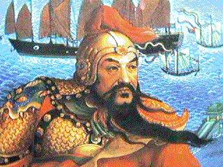
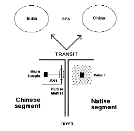
Marco Polo reported the birth of a Chinese trading camp in northern Sumatera in the late 13th century. Admiral Zheng He from Ming dynasty, built another Chinese trading camp in Malaka at the early 14th century. In both cases, the entrepot had two different areas: the Chinese fortified settlement with warehouses, and the native settlement with a palace. Both settlements were separated by a river, and functionally connected by market and harbor.
Later some of these camps developed into international exchange center of goods, and the entrepots were born. For example, in Java it was: Tuban, Gresik, Surabaya, Demak, Jepara, Lasem, Semarang, Cirebon, Banten, Sunda Kelapa, and in the Malay peninsula it was: Pattani and Malaka.
The development of entrepots was very much enhanced by the Ming dynasty's effort to put Southeast Asia under his tributary system. The Chinese settlers transplanted the basic pattern of Southern China harbor area into Southeast Asian coastal cities: the Mazu temple, and axis connecting the harbor and the temple. This primary element was the nucleus of all Chinese settlements in this region.
At the early stage, the royal city was only an agglomeration of native aristocratic compounds, surrounded by clusters of their dependent houses. The city walls were built to protect the royal native area only, and left the rest of urban sprawl outside them.
In Javanese cities the "alun-alun" (open urban central square) with a mosque, the house of native ruler, and a market nearby, were the primary element of the native area. This pattern was influenced by the Hindu-Javanese urban planning principles. In Buddhist or non Muslim cities, the inner-city center was dominated by palace and religious buildings.
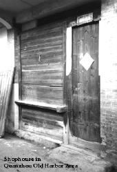
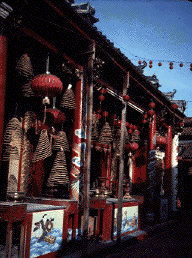
The non natives were usually forbidden to dwell inside the royal city, so they formed settlements outside the fortifications, closed to the river (the main transportation means) and the market. The largest and oldest non native settlement outside the wall was the Chinese settlement. Contrast to the low density inner-city, the built up area of the Chinese areas were usually very dense.
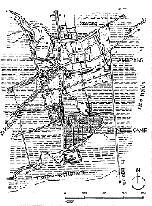
The preexisting city outside the trading post was a prosperous Chinese area, connected to the native settlements. The Chinese was the main player in the domestic economy and soon they built a mutualistic relationships with the European traders. This could be seen in the case of Malaka in early 16th century, also Batavia and Semarang in early 17th century. Later in 17th century, the small forts in these cities were replaced by larger castle and extended fortifications.
European style town was built inside the castle, with a church, open square, administration buildings, military buildings, and warehouses. It looked like a medieval European walled town, but it had more military and commercial functions, and less civilian population.
Outside the castle, normal urban activities of the preexisting city went on, and even enhanced by the rising commercial activities. The harbor facility would be upgraded, and the trade relation with Europe increased. The Chinese was still acted as the mediator between the European and the local populations.
The British, which came to Southeast Asia in 18th century after the Portuguese and the Dutch, was more a peaceful traders, compared to the two previous Europeans. They destroyed the castle of Malaka, built new forts as administrative center and military garrison in Penang and Singapore. A short British administration period in 19th century in Java had also changed Batavia and Semarang into economic centers.
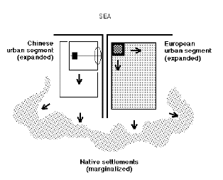
In order to control the economic role of the urban population, especially the Chinese groups, the segregation policy of dwelling areas according to different race was implemented almost in all colonial cities of Southeast Asia in 19th century. The urban society was generally divided into three classes: the European, the Chinese and other foreigners, and the native population. In some cases like in the British Straits Settlements (Malaka, Penang, Singapore), a racial group could be divided again into subgroups according to their origins. However, in the Straits Settlements (Malaka, Penang, Singapore) the implementation of segregation policy was not as strict as the Dutch's cities in the northern coast of Java (such as Batavia, Semarang).
Normally there was no clear physical boundary which separated the different zones. But still the legal boundaries had created internal densification process within each restricted zone, especially on the Chinese zone. The Chinese ethnic group became the main target of this racist policy, because the colonial rulers wanted to control or to curb their economic dominance. The over-densification would in turn led into the environmental disasters and public health deteriorations of the whole city.
On the meantime, the European zone developed freely to become a more elegant urban segment. But the worsening environmental condition of the city had forced the municipality governments to abandon their restrictive policy, and to launch improvement programs in urban sanitation and utilities.
Municipal governments introduced building codes and regulations, in order to improve sanitation and safety in the inner city. New building typology had been introduced and old typology was altered according to the new regulations (pedestrian arcades, open backyard with utility functions, fire escape, etc.).
New housing areas were planned and developed inside and around the city, to accommodate the rapid increment of urban population. The harbor was enlarged or rebuilt, some industrial buildings appeared, and the central business districts emerged in the city centers. Trade fairs were organized to accommodate the rapid growth in commerce and international trade.
Many fresh ideas from early Modern urban planners and architects were put into city plans and building designs, such as the Garden City ideas. A lot of idealism and hopes were put into the evolution of the coastal cities in Southeast Asia.
But around 1930s, the world economic recession had hampered these developments and caused stagnation everywhere. Finally, the second World War and the invasion of Japanese Imperial army to East Asia and Southeast Asia, had changed the course of urban history of this region.